English I 2019
The name East Sea refers to the sea to the east of the Korean Peninsula. The name East Sea appears in various references, such as the monument of King Gwanggaeto, old records such as Sinjeung dongguk yeoji seungnam, and on old maps. The name East Sea is clearly labeled on the late 18th-century Aguk chongdo at the Kyujanggak Institute for Korean Studies at Seoul National University. Aguk chongdo was created in the late 18th century. This map is a small-sized map similar to the Dongkuk jido made by Jeong Sang-ki, and it is notable for its beautiful coloration. The map displays the names of the seas around Korea: the East Sea, the Yellow Sea, and the South Sea. Yeojido, which was designated as National Treasure No. 1592, is composed of three volumes of illuminating manuscripts and maps created during the late-Joseon Dynasty. The first volume contains six copies of maps including a world map, a map of China, a map of Beijing and Hanyang, and a national map. Among them, Joseon ilbon ryukyu gukdo, which depicts Joseon, Japan, and the Ryukyu Kingdom (currently, Okinawa prefecture of Japan) clearly shows the names East Sea and Ulleungdo.
The name East Sea also appears on a Western-style world map entitled Cheonhado jido, which is now preserved in the Kyujanggak Institute for Korean Studies at Seoul National University. It was made during the Joseon Dynasty and was based on the Wanguo quantu by Giulio Aleni. On this map, the East Sea is referred to as the “Small East Sea,” and the Yellow Sea as the “Small West Sea.” These names were added in the Cheonha dojido by the Joseon cartographers as they did not appear in Aleni’s Wanguo quantu. Dokdo appeared on various ancient maps of Korea. It was called “Usando” during the Joseon Period. The island was marked as Korean territory on various Joseon jeondos (Maps of Korea) as well as on the Ulleungdo maps included within the maps of counties and prefectures. Dokdo, or Usando, was erroneously marked to the west of Ulleungdo on maps made in the early Joseon Period. However, in the late Joseon Period, the location was corrected, and the island was placed to the east of Ulleungdo as a result of the famous Ahn Yong-bok incident, which facilitated the communication of information about Dokdo. The Dongkuk jido by Jeong Sang-ki placed Dokdo very close to its actual location. A close-to-accurate placement is also found on the Haejwa jeondo.
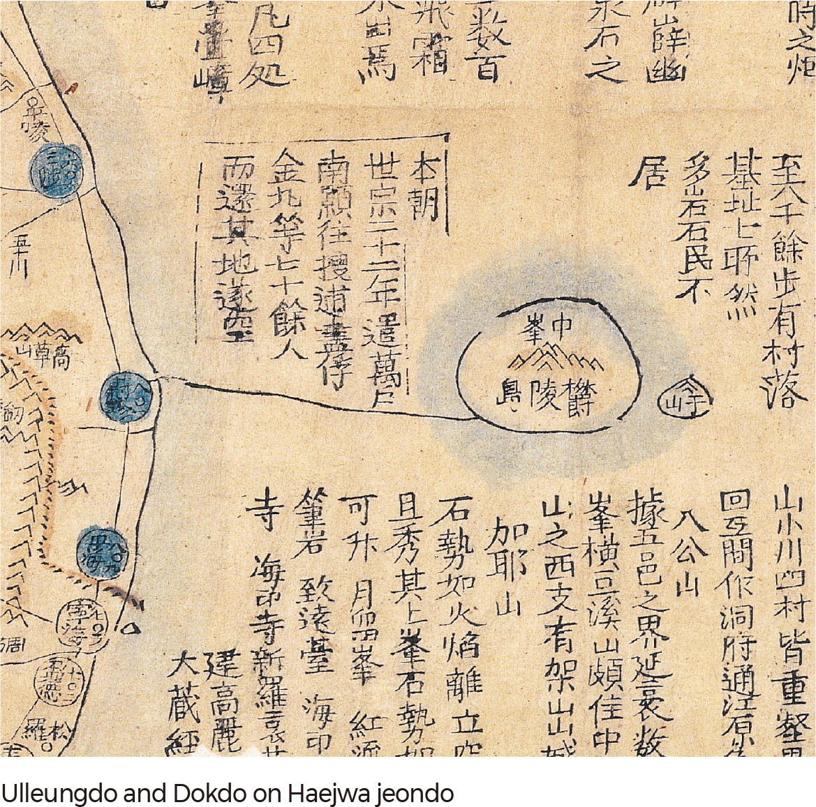
The Haejwa jeondo is assumed to have been made in the middle of the 19th century. “Haejwa” refers to Joseon, which sits to the east of China. Its format and content are similar to the Dongkuk jido made by Jeong Sang-ki; the mountain chain, the hydrographic pattern, and the transportation network were drawn in the same manner as on the Dongkuk jido. On this map, Jungbong Peak on Ulleungdo was described as a mountain, and Usando was depicted as a small islet with a mountainous peak and part of Ulleungdo’s insular area. A sea route starting from Uljin appeared on the map. In the margin is a short statement about the history of Ulleungdo and its geographic background, which is the same as the one included in the Sinjeung dongguk yeoji seungnam, a geography book.
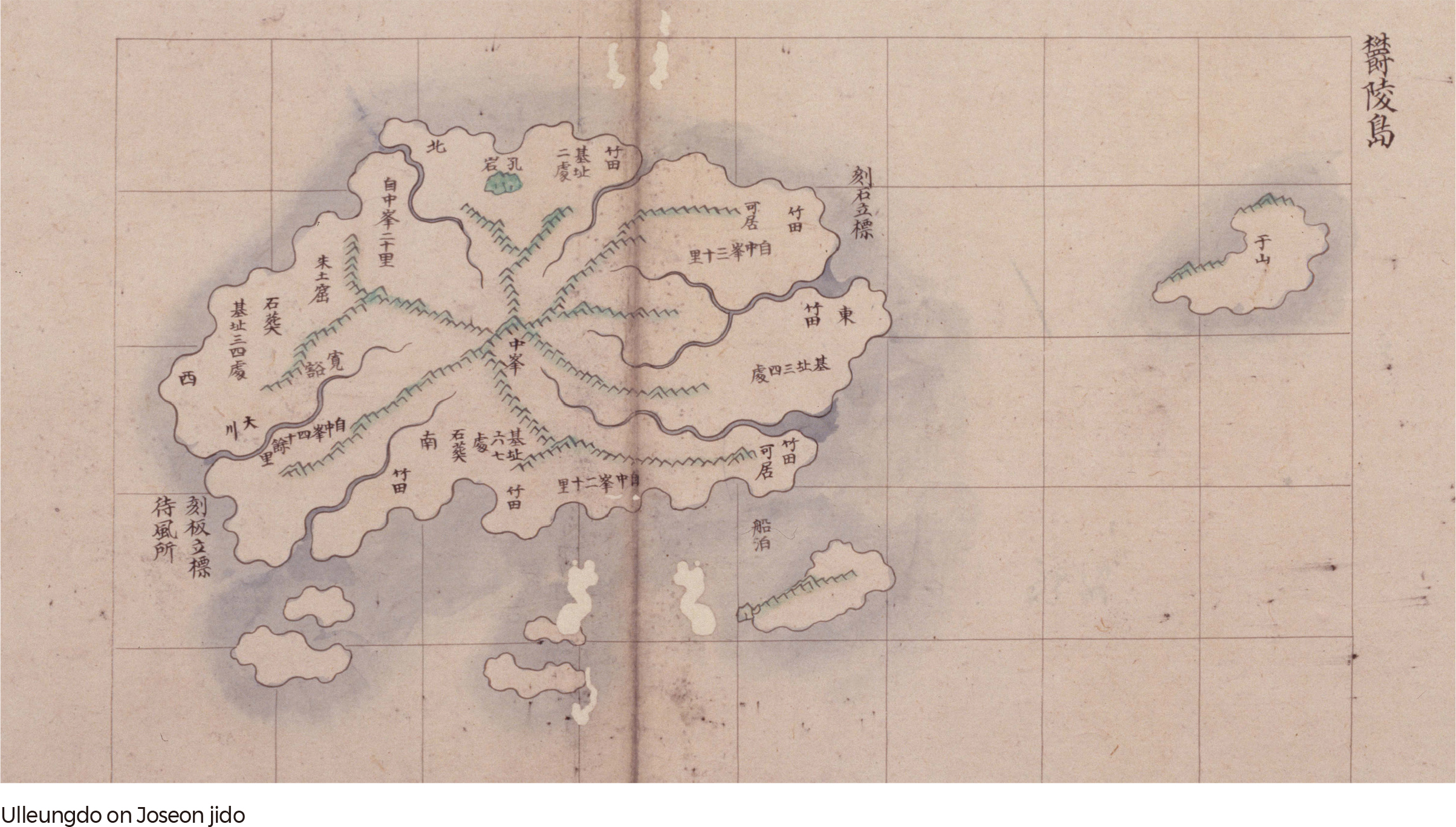
The Joseon jido of the 18th century is an atlas of counties and prefectures, including those that included Dokdo. The Joseon jido was a product of the national mapmaking project that sought to produce complete maps of Korea, like the Dongguk jido created by Jeong Sang-ki during the reign of King Youngjo. This map was drawn with a checkerboard system, and each cell was 4.1– 4.2 cm. Its accuracy in distance measurements and direction was a great improvement over the pictorial maps of counties and prefectures. Given the overall structure and content, its description of Ulleungdo seems to have been based on a separate Ulleungdo map that was compiled from previous cumulative research efforts on Ulleungdo. On this map, Usando is located farther to the east of Ulleungdo than on previous pictorial maps. Since one cell equates to 20-ri, the distance between Usando and Ulleungdo is measured to be approximately 40-ri. Because Usando is detached from Ulleungdo, it confirms that the Usando portrayed on that map is, in fact, present-day Dokdo.
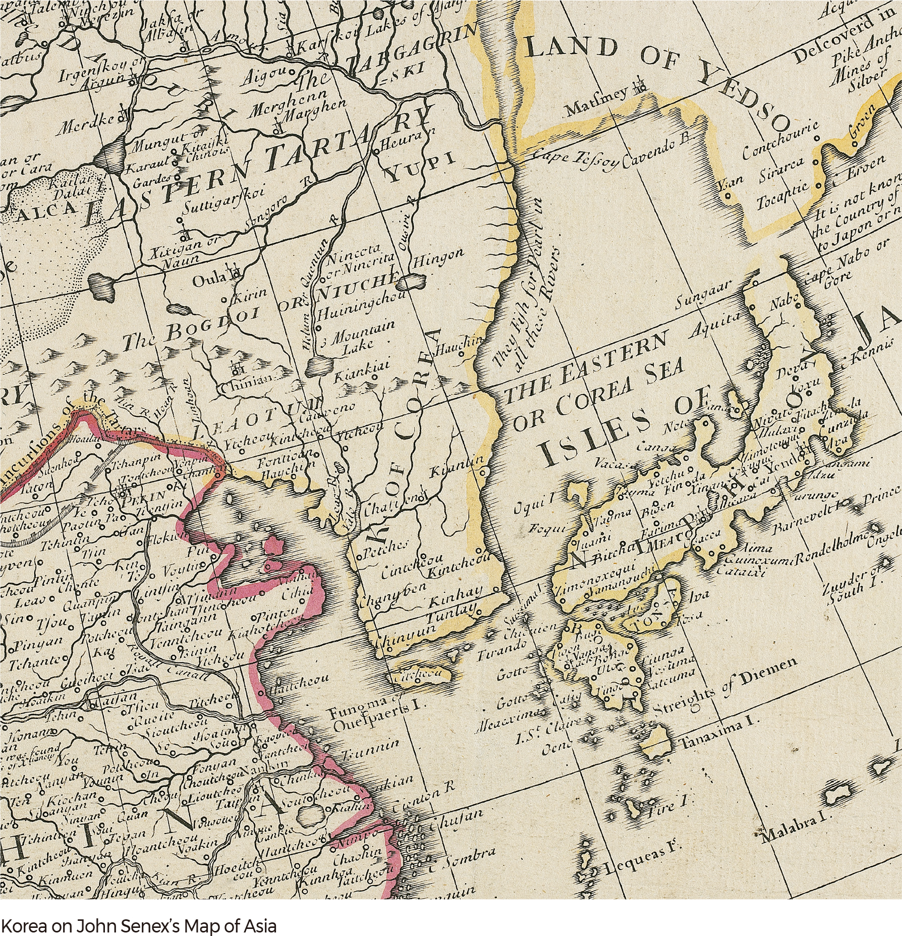
The names East Sea and Dokdo are also found on early maps produced by western cartographers. Joseon first appeared on a European map produced after the 16th century. Initially, the country was described as an island on those maps, and only over time did it take the shape of a peninsula. The name East Sea or the Sea of Korea appeared on maps, and those names refer to the present-day East Sea. A good case in point is a map of Asia made in 1720 by an English cartographer, John Senex. It is an English translation of a map made in 1705 by Delisle, a French mapmaker. Senex’s map shows a Korea scaled horizontally wider than its actual width. The country name is marked as the “Kingdom of Corea.” The East Sea is marked as “The Eastern Sea” or “Corea Sea.”
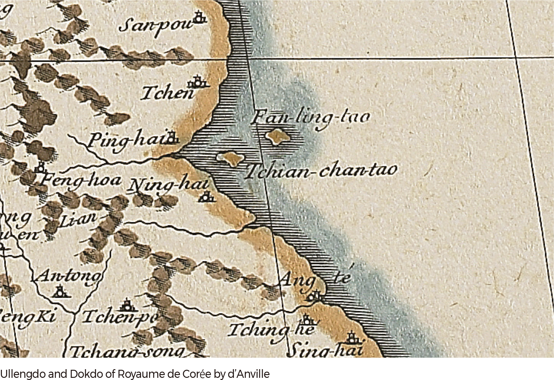
Joseon had not been mapped in great detail on European maps prior to the early 17th century, and this omission meant that Ulleungdo and Dokdo rarely appeared. Later, in 1735, Joseon was described in detail on Royaume de Corée (Complete map of the Kingdom of Joseon) by Jean Baptiste Bourguignon d’Anville, a French cartographer. D’Anville drew Ulleungdo and Dokdo in the East Sea. Royaume de Corée, which was included in Atlas de la Chine, showed two islands labeled as “Tchian-chan-tao,” referring to Usando (Dokdo), and “Fan-ling-tao,” referring to Ulleungdo. This map was greatly influential to successive maps, so many subsequent maps in France, the United Kingdom, and Germany were produced with Ulleungdo and Dokdo properly labeled.
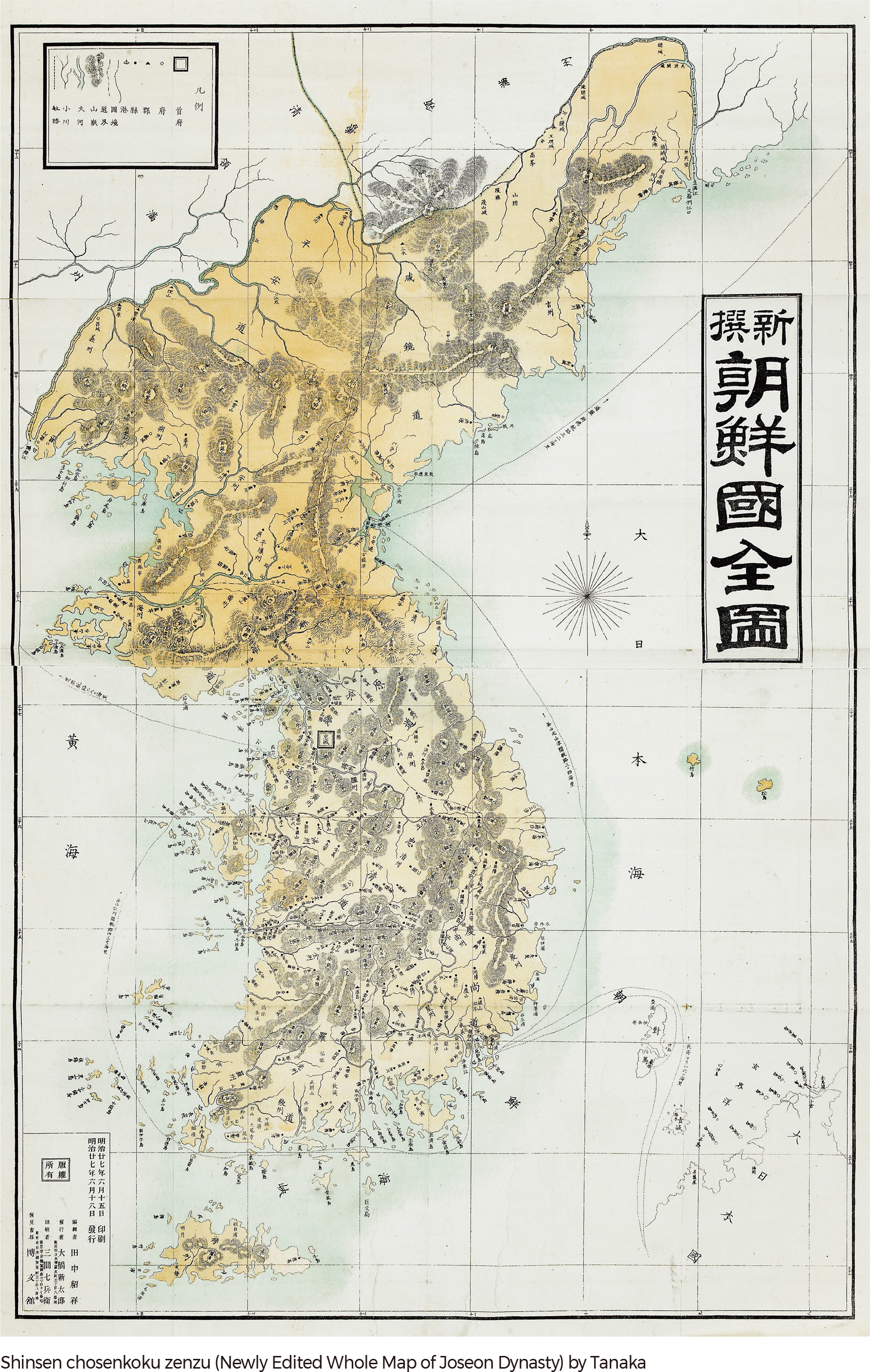
The inclusion of Dokdo as Korean territory is also found on maps published in Japan. The map of the boundary between China, Korea and Japan, created by Hayashi Sihei, clearly represents the two islands in the East Sea, Ulleungdo and Dokdo, in the same color scheme as Joseon, indicating that Dokdo is Joseon Territory. Additionally, the words ‘the territory of Joseon’ were written right next to the island. Shinsen chosenkoku zenzu (Newly Edited Whole Map of Joseon Dynasty) by Tanaka Akiyosi in 1894 labeled Ulleungdo and Dokdo as “Jukdo (Takeshima)” and “Songdo (Matsushima)” in the same color scheme as the Korean Peninsula, which shows that Japan acknowledged Dokdo as Korean territory.
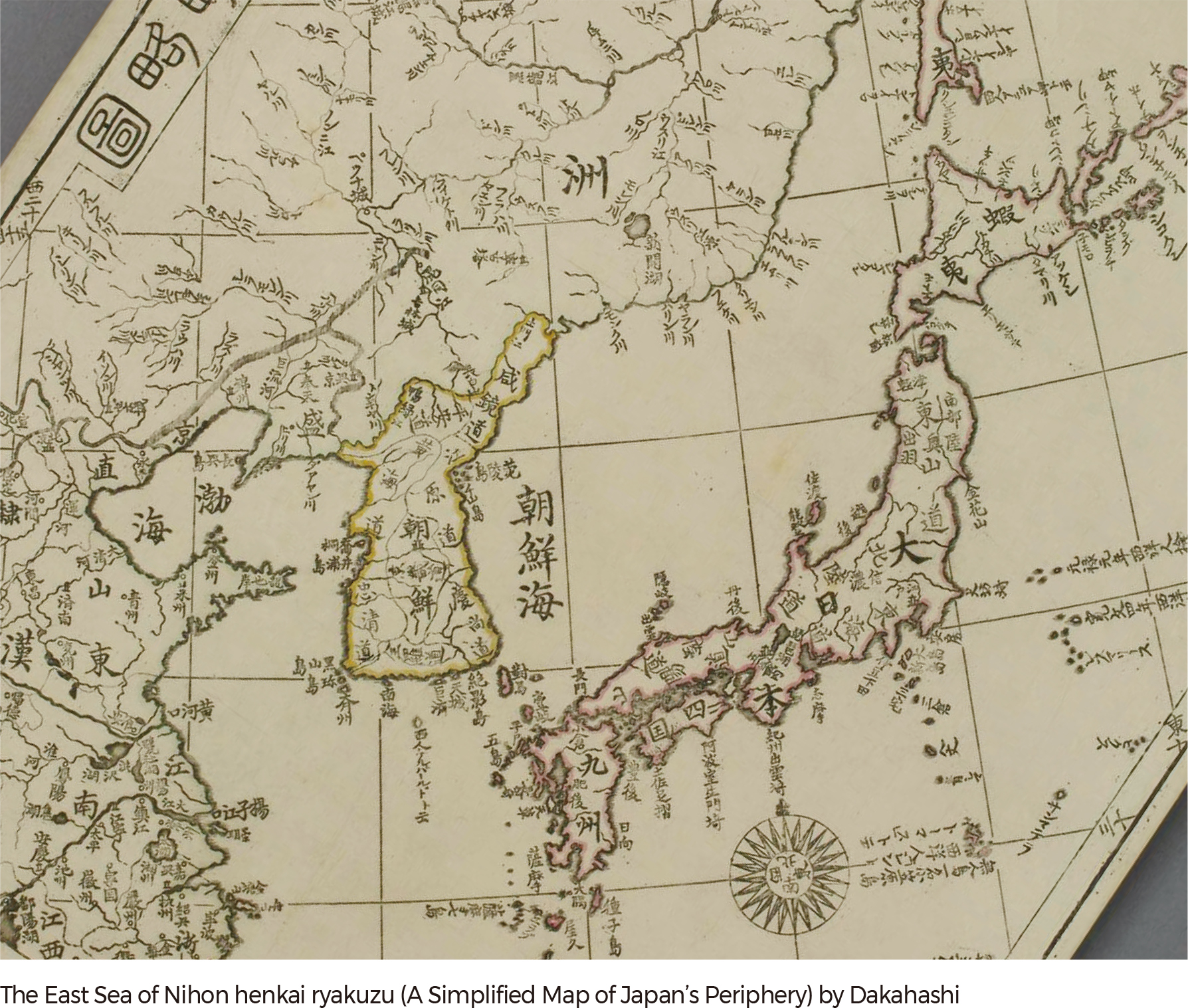
Along with Ulleungdo and Dokdo, the name East Sea also appears on Japanese maps. A good case in point is the Nihon henkai ryakuzu (A Simplified Map of Japan’s Periphery) produced by Takahashi Kageyasu in 1809. This map was the first official Japanese map on which the Japanese archipelago is placed in the center. Latitude and longitude lines were included on the map, and Japan was described and presented with surveyed measurements that were completed by Ino Tadataka, a Japanese cartographer. Maps of the Qing Dynasty of China and the map of Joseon in Huangyu quan lan tu (Atlas of the Chinese Empire), as well as other Chinese maps, were assumed to have been referenced for Takahashi's Nihon henkai ryakuzu. Again, the East Sea was labeled as the Sea of Joseon, and Ulleungdo and Usando were labeled as Ulleungdo and Cheonsando, respectively, indicating that they belonged to Joseon. |